“In Xanadu did Kubla Kahn a stately pleasure-dome decree: Where Alph, the sacred river, ran through caverns measureless to man down to a sunless sea.” Samuel Taylor Coleridge
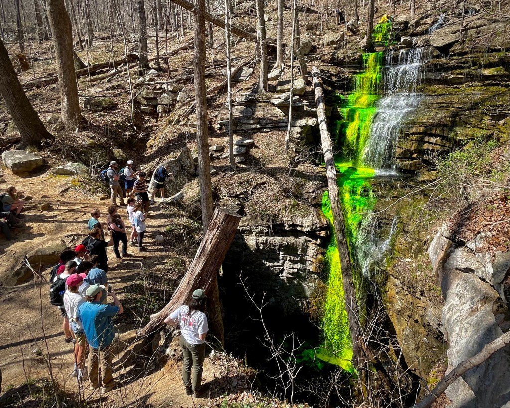
Fluorescein dye being placed into Bridal Veil Falls in Sewanee, TN as part of a United States Geological Survey (USGS) study of groundwater flow to springs in Cowan, TN that supply the community’s drinking water.
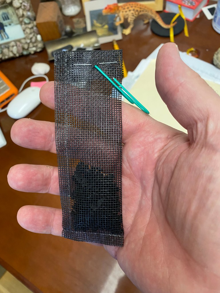
As stream water cascades off the sandstone cap of the Cumberland Plateau it washes across the limestone layers that form the lower two-thirds of the escarpment. Since the water is acidic (pH of 4.5 – 5.5) it dissolves the limestone. The water is preferentially diverted into cracks (“joints” in geology-speak) and along horizontal partings in the rock. These are enlarged into ever bigger openings and can therefore take up even more water. This feedback mechanism eventually leads to the development of caves within the limestone. Many of these caves are accessible by humans and in this situation streamflow can be observed directly. There are, however, many more situations where the cave passages are too small to enter and where the path of water flow can only be guessed. One of the great challenges for hydrologists is to determine the flow of water through inaccessible cave systems. This is important because flow paths tell us where drinking water comes from and the directions that contaminants may take underground. So how do hydrologists determine the flow of hidden water through caves? The most effective way to do is is through dye tracing. With this technique, a colorful dye such as green fluorescein is added to stream water where the water enters the ground. Where the dye reemerges from the ground downhill then marks the general path of the water in the subsurface. The reemergence can be timed to give an idea of the average flow rate underground between the two points. In a karst (limestone cavern) system the reemergence can occur at more than one location and can manifest itself as a spring or flow into a stream. It is very satisfying to actually see the dye emanating from the ground, but sometimes it is invisible due to too much dilution. To get around this problem charcoal packets can be placed into suspected resurgence points before the dye is added to the ground. Even if the dye is diluted, very small traces of the dye will be picked up by the charcoal and can be detected in the laboratory.
Typical charcoal packet used to detect tiny amounts of dye.
Fluorescein dye is harmless in the environment and is even used in medical procedures. All dye tracing events in Tennessee must be approved of in advance by the Tennessee Department of Environment and Conservation (TDEC). The amount of dye used must also be matched to the volume of water flowing into the ground at any particular location.
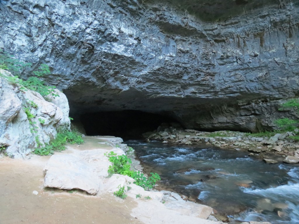
Let’s look at an example of a fairly straight forward dye tracing investigation involving Buggytop Cave, part of the Head of the Crow State Park system near Sewanee, Tennessee. The cave entrance is one of the most spectacular in the southeastern United States and boasts a vigorous stream coming out of it.
Buggytop Cave with exiting stream in the Head of the Crow State Park near Sewanee, TN.
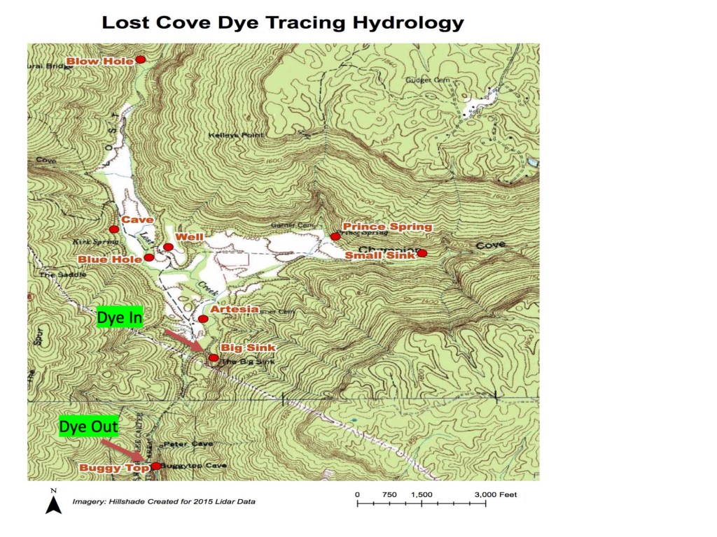
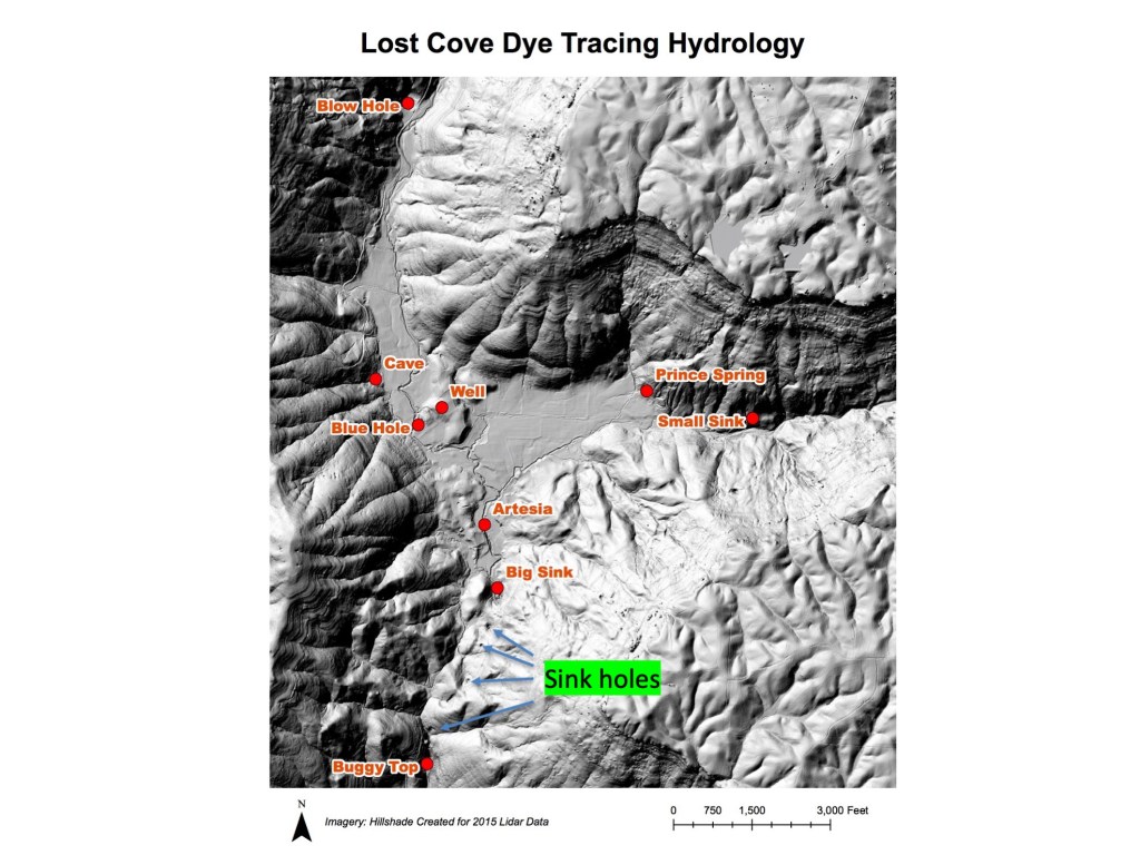
People often wonder where the stream water has its origins. It was long suspected that the water came from a large sinkhole called “The Big Sink,” which is situated about 3700 feet (0.7 miles) away higher up on the flanks of the Cumberland Plateau at the end of a large valley called Lost Cove (see map below).
Topographic map of a portion of Lost Cove showing location of dye injection (Big Sink)and Buggytop Cave mouth (where the dye came out) to the southwest.
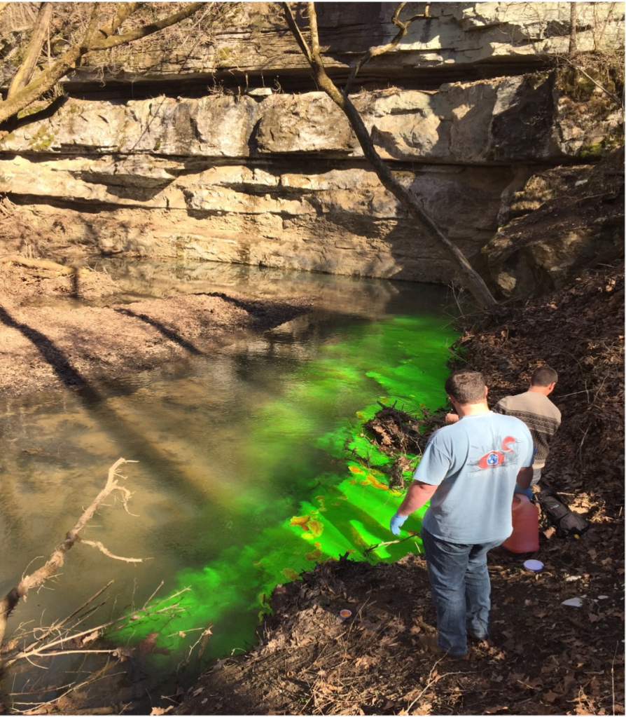
During heavy rains the Big Sink acts like a huge drain for a large portion of Lost Cove. Does the water make its way southwestward under a ridge, run through Buggytop Cave and then exit at the cave’s lower entrance? To find out, some students in my hydrology class injected fluorescein dye into the Big Sink, while others were stationed at the opening to Buggytop Cave.
Students injecting dye into the Big Sink.
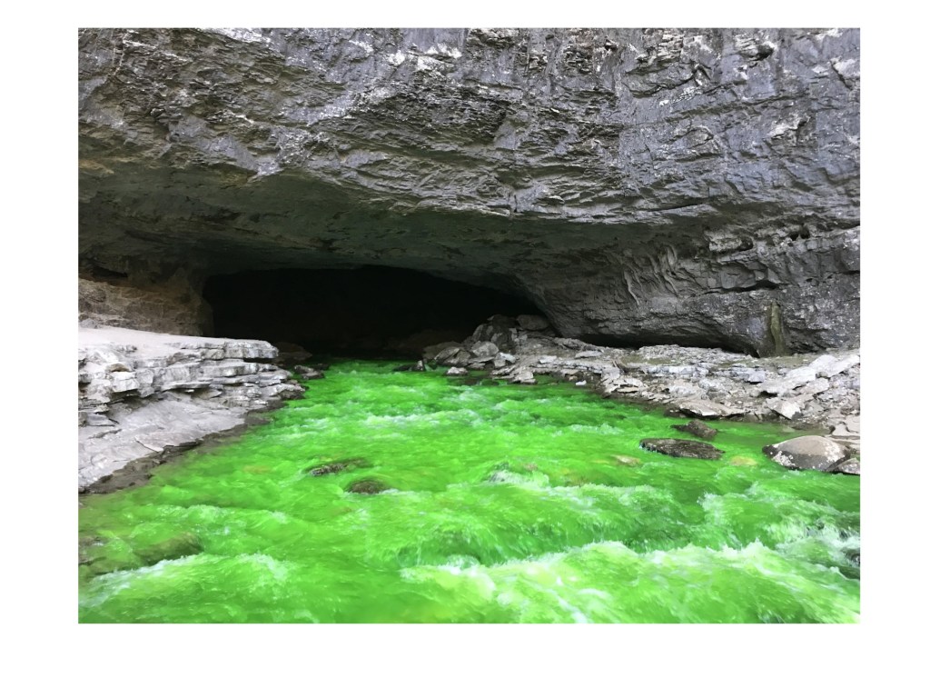
After 20 minutes a radio call from students stationed at Buggytop Cave confirmed the arrival of the dye there. Thus we know that at least a large portion of the streamwater in Buggytop Cave comes from the Big Sink in Lost Cove, and that it takes about 20 minutes for the water to make this underground journey of about 0.7 miles. The time likely varies with flow volume.
Dye emerging from Buggytop Cave after its 20 minute, 0.7 mile journey underground from the Big Sink in Lost Cove.
A LIDAR image of the area shows a tantalizing line of sinkholes between the Big Sink and the upper part of Buggytop Cave. Perhaps this represents a mostly collapsed cave system along which the water moves, but that is too narrow for human exploration.
LIDAR image of study area showing four sinkholes in a line between Buggytop Cave and the Big Sink.